Maps on this Site
Many of the maps on this site have some interesting features that are not readily apparent unless you do a little experimenting. They are not your typical static maps like we find in print. These maps are interactive.
While the scale of the maps was chosen to give a context that the user can use to orient themselves, the scale is actually adjustable. The left hand bar has + and - buttons which you can click on to zoom in or zoom out respectively. Rather than use the buttons (or if they are not present), you may be able to scroll up or down with the mouse while the cursor (which looks like a hand) is on the map to accomplish the same thing. What's nice about using the mouse to zoom is that the map is centered at the point where the "hand" cursor is. If you are not careful about the cursor placement before scrolling, zooming in can cause the location you are interested in to "fall off the map". Just zoom back out and place your cursor at the point of interest before zooming in again.
You can also pan in any direction on the map. This means dragging the map around within the display window. You can pan the map by placing the "hand" cursor over a location on the map and then scrolling the map in any direction while the left mouse button is held down. Let's say you wanted to see the next major street to the east but it's not showing on the map. So, to pan to the east, hold the left mouse button down while you scroll to the left. This drags the map eastward where your missing street is.
Zooming and panning on the map are pretty cool, but there's something else you can do which is nice. In the upper right hand corner of the map is one or more buttons. The Map option shows a typical map with roads and maybe other features. Another option is Satellite. If you click on Satellite, the map comes up with a satellite image of the current view. Depending on the locality, the satellite imagery is quite clear. That means that some of the churches (or other features) can be seen if you zoom in enough and pan to the correct location.
Some maps on this site have markers of churches. Clicking on the marker may give you the address of the church. A word of warning about the markers: If you have zoomed out too much, the markers might not be in their correct locations. For example, a church in East St. Louis, Illinois looks like it is in Missouri at a certain zoom level. If you zoom in closer, you will see the markers move closer to the intended location until they are "at the doorstep" of the location they mark.
A couple of maps on this site have map overlays. This means that an image of a "paper" map is superimposed over the modern map or satellite imagery. These paper maps are usually 19th through mid-20th century maps of the titled location. This lets you compare features of old against new like roads and their names. As digital images are involved, it takes time for them to load over the modern map-- so be patient. These maps are also pannable and zoomable as discussed above. As you pan, you may notice that the "paper" map overlay ends-- just as a paper map has finite edges. Zooming is somewhat controlled. If you zoom out too much, the overlay map disappears because you wouldn't be able to see any details on it anyway. If you zoom in too much, the overlay map again disappears because overlay images get too grainy to be useful. In addition, it places more demands on the server.
These overlay maps have a property called opacity. It is a fancy term for how "strong" the overlay image will be. When you open one of these map pages, the default opacity is 80%. These map pages have a slider scale in the upper right hand corner near the other buttons so that you can adjust (click and drag the slider left or right) the opacity. At the far right, 100%, only the overlay image is visible. At the far left, 0%, only the background map shows. It is a nice feature to play with. One small problem is the slider is light in color and maybe overlooked if it is sitting on top of a light overlay map so remember it is located in the upper right side of the map window. The bigger problem may be browser compatibility issues. The maps were designed using Google Chrome and display as designed. MS Internet Explorer (MSIE) might not display them as nicely. MSIE is notorious for not being standards compliant. Commercial websites might choose to design work-arounds for MSIE. The MSIE display issues are minor enough that I think you can live with them. You can always upgrade to a good browser.
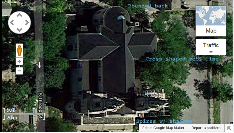
As I mentioned elsewhere, the church addresses given on this website are not usually the addresses of the church building itself since they don't have a mailbox. Instead the addresses are those of the rectory which may be near the church structure. From the satellite view, it might be hard to discern which buildings are churches as the view is largely two dimensional. Generally churches are larger structures. Some have cross structures in the roof line. Some have rounded back ends. Depending on the time of day when the satellite image was taken, the shadows of the spires and cross may be cast on the ground.
Here's the satellite image of St. John of God Church in Chicago. The features mentioned above that help you decide this is a church building are identified on the image.
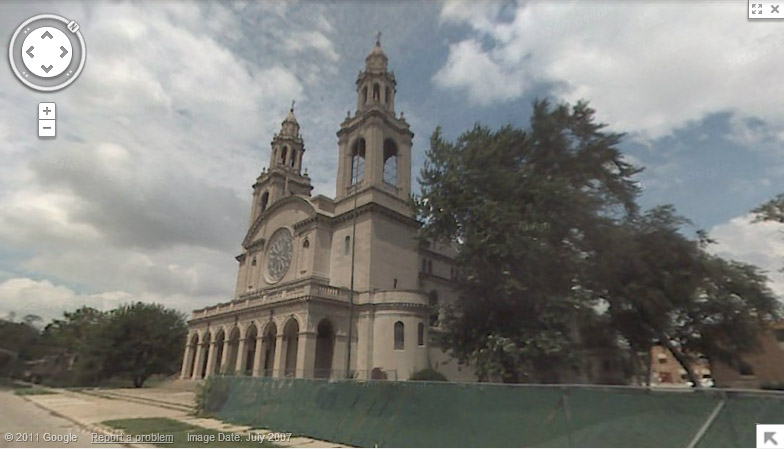
Here's a photo of the same church from July 2007 that is part of the Street View option in Google Maps. Street View is not available on the polishfamily.info site maps.